
The whole concept of The Lost Highway revolves around our nostalgia for highway history. Think of the roads that you took as a child, if you can remember that far back, and how things looked then, to how they look now. Gone are the days of two lanes of twin-slab concrete, the days of diners and mom and pop stores, they days of the question "where does that highway go?" Who has time for it anymore? Replaced with the hectic and sometimes chaotic suburban lifestyle and landscapes, this concept is left to memory and historical records, as more and more growth pervades along our modernizing roadsides.
The idea of The Lost Highway is our search for remnants of a different time, a different time in highway history, and even overall history. Take for instance, U.S. Highway 90 between Bay Saint Louis, Mississippi and New Orleans, Louisiana. This stretch is one of the best showcases of a truly lost time period with many remnants still preserved today. The highway has lost most of its luster, as Interstate 10 to the north and west has taken on the role for travelers along the Gulf of Mexico coastline. Left to decay are pockets of buildings ranging from gas stations, diners, motels, tackle shops, to a full blown casino. In addition to all of the commercial structures, a bounty of old style truss and lift bridges can be found along the roadway over the various waterways of the swampy terrain. Our ideology of The Lost Highway does not end here.
We expand our focus to include never used or previously used pieces of freeway infrastructure as well. The initial pioneers of the Interstate system has grandiose goals for a network of highways interlinking center city with rural countryside. Most of this original plan was constructed, as land was easy to obtain. Talk about the same results for inner cities of the northeast and Midwest, and you get a completely different take. Freeways were seen as the culprit of flight outside the city by residents to the fledgling suburbs. In addition, freeways were seen as the bane of existence of many inner city neighborhoods, as the right of way necessary was taken from residents directly in the path of the route. Prime examples of this power of eminent domain are found in Boston, New York, Philadelphia, Baltimore, and Washington, DC. The higher population density and overall street grid led to more destruction of neighborhoods in the wake of the new Interstates. So where does the Lost Highway play into all of this? Well, the battles between government and residents were not always won by the highway planners and engineers. And when these battles were won by the sides of the neighborhood leaders, the highways were often literally stopped in their tracks cold. Interstate 95 had to be rerouted several times at the hands of defeat due to neighborhood upheaval of the original highway plan. In Washington and Boston, the convoluted paths of the east coast Main Street are the result. But what is so lost about this? Well, small portions of roadway were constructed as if Interstate 95 were to plow through the heart of those two cities as planned. When the proposals were officially dropped, those sections were either abandoned, or turned over to lighter duties. In the Boston area, the portion of Interstate 95 never opened was left to decay. It can be found at the interchange of Interstate 95 with Interstate 93 in the southern part of the metropolitan area. In the Washington, DC area, a segment of planned Interstate 95 roadway now serves a park and ride lot northeast of the city.
Photos and stories surrounding Lost Highway concepts are welcomed. If you have photos or stories to add to existing coverage, why not send us an email? Most of what we receive, we end up posting on the site. If you are interested in searching for Lost Highway remnants in your area, here is what to seek:
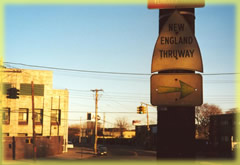
| Signage: This example looks at a New England Thruway trailblazer on 233rd Street in the Bronx, New York. The New York Thruway designation was dumped some 20 years ago. However, if one searches hard enough, vestiges such as this spade can be found. Other examples of signage to search out involve route shields on previous alignments, shields from terminated routes still posted, old black on yellow stop and yield signs, mileposts left over from an original route (a milepost 250 marker is posted on old U.S. 31 in Birmingham, Alabama for instance), among others. Old style infrastructure still in use:
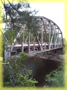
Truss bridges are rapidly disappearing from the highway landscape in the 21st century. However, if one looks hard enough, in a remote area or in an old part of town (or city), one can come across a relic of the past. This photograph looks at a truss bridge for Mississippi 57 over the Black Creek in southeast Mississippi. Other types of infrastructure to be found include old concrete arch bridges, old concrete guard rails, mid 20th century lighting fixtures, mid 20th century traffic light assemblies, etc.
| 
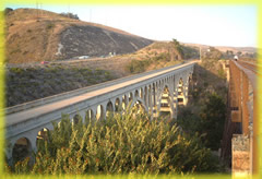
Abandoned Bridges: | Oftentimes a bridge and the associated alignment will be abandoned when a newer more modern structure is built nearby. Additionally, bridges are abandoned when structural defaults are found with costs too substantial to justify repairs. These bridges are either closed all together or bypassed with a newer span. The photograph displayed shows the former U.S. 101 route across the Arroyo Hondo Bridge. Notice to the left Interstate 5, the freeway that replaced most of U.S. 101 from Los Angeles southward through San Diego, California. Abandoned Roadways: | Probably the easiest facet of Lost Highways that can be located are segments of abandoned roadway. The top of the list is original twin-slab concrete, used for many of the original U.S. Highway alignments back in the 1920s and 1930s. Oftentimes, the original pathways included many twists and turns, following various property boundaries at the time. As highway speeds increased, and engineering practices modernized, many of these kinks were ironed out, leaving particular sections of the original alignment abandoned. In other cases, such as this photograph (which shows old U.S. 99 in the Imperial Valley of southern California), original alignments were bypassed nearby by more modern roadways or freeways. 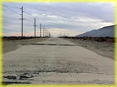
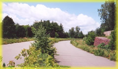 Abandoned Freeway infrastructure: Abandoned Freeway infrastructure:The most difficult of Lost Highway finds, abandoned freeway infrastructure is not so easily found. The reason being that most of the cancelled proposals of new freeways never resulted in any highway construction. Meaning, that most of the lost freeway material to be found is leftover from projects that were cancelled after initial construction commenced. This image shows a curved portion of abandoned Interstate 189 in Burlington, Vermont. This freeway is a prime example of a freeway project cut short. Originally Interstate 189 was to turn northwest of the current one mile alignment and follow the lakeshore northward near downtown. At the time, it was thought to be a great idea, because Burlington was nothing more than an industrial city, and the usefulness factor of the freeway was high. As the city economy transitioned from industrial to tourism based, the concept of a freeway viaduct obstructing the stellar view of Lake Champlain and the nearby Adirondack Mountains was blasphemy. Therefore the highway was no longer considered a sensible option, and the plans were cancelled. This occurred after a short extension was pre-constructed in anticipation of the overall Interstate 189 scheme. Other lost freeway concepts include: abandoned interchanges and ramps, stub roadways/ghost ramps for never built freeways (two examples can be found in downtown Saint Louis for the never built Interstate 755), and signage stemming from the initial completion of the freeway (sometimes freeway destination cities change depending on the time period). | ||||||||||
Posted July 30, 2002
The Lost Highway is copyright © 2005 by Jeffrey Carlyle. All photographers retain rights to their photographs. The Lost Highway was originally developed by Andy Field and Alex Nitzman for AARoads.